25 July 2017

South West US (Bus tour)

Breaking the rules here.
We had just finished an absolutely stunning and most memorable 31 day trip through the Eastern Sierra Nevada of California (in their -then- hottest summer on record). I started this blog with a view to only post bushwalking/hiking/tramping/trekking trips, but this one so rated a mention (and it did have the odd little bit of walking in it) that I had to post about it. Bindlestiff Tours (there are plenty of companies out there, but we think we struck lucky with these guys) do a great 3-day minibus tour out of Las Vegas (and after visiting Vegas, there's nowhere else you want to be but out of it!) of Zion National Park, Bryce Canyon (right), Antelope Canyon, Monument Valley (including the most amazing sunrise you may ever see!) and the Grand Canyon. My most accurate description of the trip is jaw-dropping. They are all great places to visit (and spend much more time than we did on our whirlwind tour - so if you have your own wheels, just give yourself at least a whole day at each place).

Relief filled us as we left Las Vegas (we're not bling people) and we headed from Nevada through the top-left corner of Arizona to Utah and the Zion National Park. Carved out of sand deposits that had turned to stone, Zion canyon was stunning to behold. Would have loved to hiked through more of this, though it was spanking hot when we visited.

On the same day, we had a bit more time at Bryce Canyon (also in Utah), less a canyon and more a hillside that is decorated with the most amazing formations (called hoodoos).

The following day we hit Hoover Dam (a little boring from a bus, would be more fun in a boat) and then Antelope Canyon (now in Navajo Nation, surrounded by Arizona) - a real highlight. Being on the tour allowed us to skip some of the queues, but it is definitely worth queuing for! The Navajo guides are hilarious in their tour-group leadership, based largely on one-upmanship with other group leaders. If you allow yourself to be distracted from the stunning beauty of the the canyon, it would be easy to feel like you're being pushed through a sausage machine, but we were completely captivated by the colour and shapes, not to mention entertained by the guides. 

Next major stop was Monument Valley (still in Arizona) for an overnight camp. The tour in the afternoon was truly very nice , eventually getting out and away from the crowds and then with some lovely musical moments from the two Navajo guides, but the definite gob-smacking, jaw-dropping, heart-stopping highlight was what greeted us in the morning as we climbed out of our tents at six in the morning... (here are the West and East Mittens).
Having harvested several dropped jawbones from the surrounding landscape, day three led us on to for me the most moving geological formation of the whole trip, the Grand Canyon.
The Grand Canyon is one of the earth's monumental reminders (Uluru is another) of our fleeting existence in this universe. On our most bored (or depressed) days we might think that our lifetime is overly long, but if you get to glimpse the depth of time shown in the rocks of the Grand Canyon (and there are other places in the world that do this too) you can feel truly insignificant! Hopefully that is liberating in it's own way...


As seen on Andrew Purdam's Bushwalking Treasure Box blog.
Disclaimer: The information given is of a general nature only and whilst all care has been taken, no responsibility can be assumed by the author.Conditions change, regulations change. Any reader doing these hikes after reading these notes must show due diligence and be experienced enough to take responsibility for their own decisions and actions.

18 January 2017

Sierra High Route/Mt Whitney - Days 23-31

Day 23, hiked down to the valley and back up to Taboose Pass to pick up our final food drop. Jeff was again early, even though the climb up to Taboose Pass from the road end is 1820m/5970ft, and this time accompanied by his dogs (which are allowed right up to Taboose Pass)! Most of the rest of the journey was very straightforward, following the JMT/PCT towards Mt Whitney, crossing a series of passes.
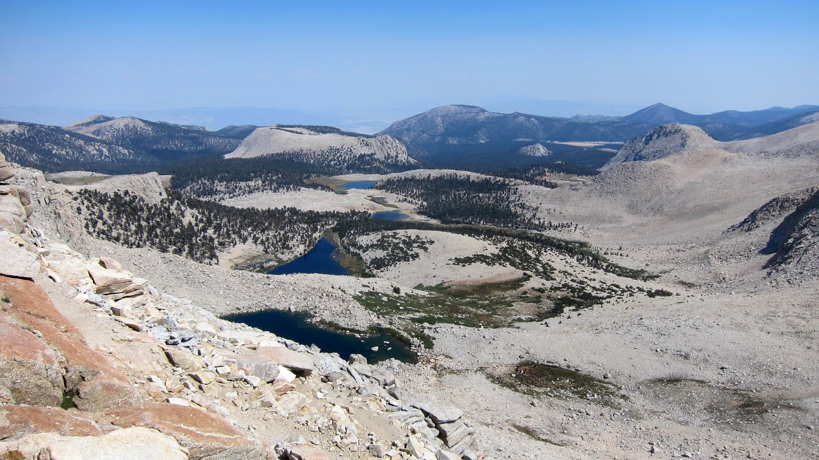
This day we crossed Pinchot Pass
(pictured above, and from where we are looking north) (3693m/12120ft), and then commenced a very long descent, which didn't stop til the next day. Whilst we were tempted to drop down to the Twin Lakes below Mt Cedric Wright, we found a spot next to a pretty lake close to the trail (pictured left, looking south towards Mt Clarence King - which we'd get pretty close to, around its back, by the end of the next day). But the water was starting to dry off such that there was very little running water to speak of.
Day 24 was to a long stretch as we spent 11 hours from campsite to campsite, travelling nearly 19km/12mi (and dropping and climbing over 1200m/3940ft each direction) from above Twin Lakes to Sixty Lake Basin, east of Rae Lakes. The (700m/2300ft) descent down Woods Creek continued until late morning, followed by the inevitable ascent having crossed the creek to follow a different watercourse back up to maintain our southward trajectory. This took us past Dollar Lake, yet another Arrowhead Lake and the spectacular Rae Lakes, dominated as they were by Fin Dome. These four lakes all had a slight green tinge, quite possibly due to higher nutrient content from humans. The Rae Lake campsites looked a little love-worn, so we continued west to Sixty Lake Basin, which meant climbing another small (200m/650ft) pass late in the day.
The Basin (above at dawn the following day) was well worth the effort though, with a much more unsullied feel to it, as we camped right around on the opposite side of Fin Dome (on the right of the picture).
Day 25 we crossed back into the Rae Lakes basin and then continued up to Glen Pass for an early lunch before dropping yet again, this time towards Vidette Meadow, ultimately 700m/2300ft below. The southern passes however were all much easier to negotiate than the Sierra High Route passes, on account of the switchbacks engineered in all the tracks. We traversed high above Charlotte Lake (left) before dropping to traverse the crossroads going east to Kearsage Pass, north from whence we came, west to Charlotte Lake, and south to Bubbs Creek and Vidette Meadow. This patch was as hot, dry and desolate as any we had come across so far. Waiting for a food drop there must feel like waiting for Lucifer himself. Vidette Meadow was spacious and treed, but the amount of windfall logs made one a little nervous, especially when a brief thunderstorm blew through.
Day 26 started with an 1100m/3609ft 1:10 gradient climb (right)  to Forester Pass (4006m/13143ft). As we ascended, we could hear more ominous rumbles from over the pass, and by the time we crested it at noon, it had started to lightly snow. Quickly donning warm and waterproof clothing (as best as our ultra-light preparations had allowed) we marched/hared down one of the more precarious switchbacks on the JMT/PCT, to get into the shelter of the forest. Not stopping for lunch for fear of getting too cold, we made camp by mid-afternoon, set up our tent, cooked up a hot soupy lunch and enjoyed being in our tent for most of the rest of the day. The cold blast had blown over, and we had reached warmer climes.
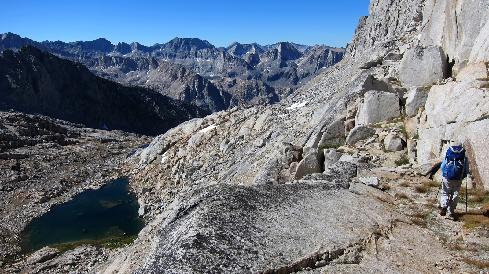
Chatting with a friendly neighbour - Michael - back at Barrett Lakes, we were inspired to visit the lakes on the Upper Kern Loop Trail, which loops west off the JMT north of Tyndall Creek campsite. So with a day up our sleeves, we took the time to head to the Upper Kern river, and then take the circuit clockwise to Lake South America, and come back to camp over the little pass (from which we could see Mt Whitney). It took us about 7 hours over 13km/8mi, and involved over 900m/2950ft climbing and the same descending back to camp. But it was sure pretty!
Day 28 we pushed on over the sparse and pretty Bighorn Plateau and increasingly sparser and sandier terrain to Crabtree and up to Guitar Lake, nestled below Mt Whitney. We got to Crabtree by lunch time and had hoped to get the scoop from the local ranger on whether we could camp up at Guitar Lake or not, but they were not to be found.  Accepted wisdom is that if you're on the PCT, then you're allowed. There were "poop bags" for folks heading out over Whitney Portal, to try and reduce the amount of human waste on Mt Whitney. They're not really intended for hikers going in other directions, but we figured it had the same positive impact, so grabbed some and headed up. Guitar Lake is a very pretty place to stay, though pretty busy due to the whole Mt Whitney thing going on...
Day 29 was a doozy of a day. We got up about 4:45am to be on our way by 5:30am, heading up up up 960m/3150ft to the summit of Mt Whitney (4423m/14505ft, left, look for the shelter on the flat spot), the highest peak of the contiguous United States. Whilst we were getting ready, we could see scores of head-torches bobbing their way up the trail, which gave us a good idea of the route, it being illegible from below the afternoon before.
It was a long, slow climb (3¼ hours) over yet another engineering feat as the route picked its way through a whole mountainside of talus (right). I'm not sure why there aren't more reports of altitude sickness for all the folks who climb up straight from Whitney Portal without any acclimatisation. We were certainly puffed! Below is the view south east from the summit, those lakes are about 900m/2950ft below, and Whitney Portal another 1100m/3600ft further down.

It took 2½ hours to descend back to Guitar Lake, where we had lunch, packed the tent and our now hot bear canisters, and continued down to Crabtree, and lower Crabtree Meadow, where in hindsight we should have stayed. However we pressed on, hoping to find a site by a stream, but there was no water for three hours, so we crossed Guyot Pass and continued to the oasis of Rock Creek. By the end of that day, we had hiked 21½km/13mi, climbed 1697m/5567ft, descended 2299m/7542ft, and been up and active for 13 hours! Phew! But what a magnificent day!
The huge effort of that day paid off the following day (30), as we had a shorter time of it hiking via the pretty Soldier Lakes to Army Pass and New Army Pass. We remember walking out of Rock Creek and thinking to ourselves "bacon!". Ten minutes later we passed the Ranger's Hut...

Our final pass, New Army Pass was - like many passes before - over 800m/2630ft above our breakfast spot. It revealed the Cottonwood Lakes spread below us, but 360m/1120ft below! Thankfully the switchbacks. so characteristic of this southern part of the Sierras, made the descent easy though a little tiresome.
And so our final day of our Sierra High Route/Mt Whitney hike, Day 31, dawned with the sun peeking over Long Lake. And like every other day, it got hot. By the end of the day, we had spent 31 days hiking up 27,796m/91,194ft (over three Mt Everests, from sea level) and down 27,665m/90,764ft. We spent 18 of those days attaining an elevation above 3,500m/11,482ft, and hiked 373km/232mi.

Prev (Days 16-23)   Index   ...

As seen on Andrew Purdam's Bushwalking Treasure Box blog.
Disclaimer: The information given is of a general nature only and whilst all care has been taken, no responsibility can be assumed by the author.Conditions change, regulations change. Any reader doing these hikes after reading these notes must show due diligence and be experienced enough to take responsibility for their own decisions and actions.

15 January 2017

Sierra High Route/Mt Whitney - Days 16-23

Day 16 was one of our hardest days. By late morning, we had bumped into two coyotes (right), picked up our food drop from Jeff  at Piute Pass (who had very conveniently arrived over an hour earlier), and headed past Muriel Lake and Goethe Lake towards Alpine Col. There are three high crossings over the Glacier Divide: Snowtongue Pass (as suggested by Roper, followed by Andrew Skurka and avoided by many!), Alpine Col and The Keyhole. We opted for Alpine Col (at 3768m/12362ft a little higher than Feather Pass and a little lower than Snowtongue Pass), though we had met folks describing it as traversing rocks the size of Volkswagen Beetles! Turns out they were right.
Even getting to the base of the ascent is hard work, as Goethe Lake is lined on the eastern side with rocky Beetles. Having clambered over those, we still had climb 240m/790ft of boulders, talus and scree to pass through Alpine Col (pictured left). Yet more talus and picking our way over boulders, and we found our way to Darwin Bench, a real oasis after all the earlier rock. Even though we spent nearly 11 hours "on the track" (including picking up and packing our food), we barely travelled 12km/7.5mi. We climbed 832m/2730ft and descended 263m/2500ft. But the terrain was some of the toughest of the whole hike, and of course with freshly laden packs!
Next day we made a quick visit to Darwin Canyon before dropping down to the JMT on an at times indistinct trail that then improved so much we thought we were already on the JMT! We proceeded to Evolution Lake (right), one of the prettiest lakes on the whole hike.


Beyond it was another pretty lake, Sapphire Lake, and the gorgeous Wanda Lake (left), named after one of John Muir's daughters. We had wanted to camp there, but couldn't see anywhere (there's one spot on the opposite side, apparently, but no trees), so we pressed on up to Muir Pass (3644m/11955ft), which crosses yet another divide, the Goddard Divide. The "Muir Hut" is a shelter built at the pass, which would be a good port in a storm.

From Muir Hut, it was less than an hour down to Lake Helen (another of Muir's daughters), where we found a pretty (though bare, as is usual above the timberline) campsite. At 3561m/11683ft, this was to be the highest campsite of the whole hike, higher even than Guitar Lake below Mt Whitney.
Day 18 commenced with a descent effectively following the Middle Fork of Kings River from the headwaters at Helen Lake down Le Conte Canyon. A beautiful (and tall) descent it is, too, dropping 1049m from Helen Lake to Little Pete's Meadow, where we gave ourselves the afternoon off. This was our first half day of walking (ignoring ending the northbound leg, and starting the southbound leg) and we welcomed the rest. We also welcomed all the interruptions as several grouse (or ptarmigan), a mule deer and her faun wandered through the campsite. Little Pete's was a good place to stop, as we enjoyed a mid-afternoon sunset due to the proximity of Langille Peak, which towered 970m/3180ft above us, casting a welcome shadow.
The start to day 19 was really well engineered, as we had a steep 600m/1968ft climb up to Dusy Basin. With an early enough start, we accomplished all but the last ten minutes in the shade of the valley wall.

Dusy Basin was pretty enough, though starting to feel the mid-summer heat. However as we were climbing up to Knapsack Pass (the gap about dead centre above, just right of the largest peak - Columbine Peak), we were visited ad hoc by an iridescent hummingbird, which flew up to us, inspected us, said "what are you doing here?" and then flew off. A magical moment. 


Knapsack Pass was one of the easier passes (we made it a bit harder by diverting from the straight-up-the-middle route to go a nearby tarn for lunch), and we made camp at one of the Barrett Lakes, having just put back on all the elevation we had lost the previous day. 
We watched the light change on North Palisade (left) as the sun set. Not long after, the moon rose. And then much later, the sun (right) rose...


Day 20 crossed two passes, Potluck Pass and Cirque Pass - both interesting in their own ways. Potluck Pass (left) had a very steep southern side, starting off with a ramp which basically devolved into a scree-ride. Cirque had a choose-your-own-adventure route which was largely easily navigated, descending to our campsite, a white knoll above the JMT and west of Palisade Lakes. 
Now at the two thirds way mark, we dropped quickly down to Palisade Lakes, only to immediately commence the 450m/1475ft climb to Mather Pass (pictured right - with the Palisades and Palisade Lakes in the background). At the bottom of Mather Pass, we were to part ways with the Sierra High Route (which was to head south-west to Kings Canyon) and follow the JMT/PCT (roughly southwards, with some side diversions) towards Mt Whitney.
Having turned from the Sierra High Route and toddled over to Split Mountain tarn, we contoured along a variety of benches to Cardinal Lake (pictured left), where we were treated to some interesting light as the sun later set, and the moon (much later) rose. Cardinal Mountain is the right of the two white "blond tips". Our little tent is tucked in on the bottom right.


Next morning (Day 22) we dropped back down to the JMT before climbing back up to Bench Lake where we had lunch. This was one of the longer days - mostly because of the side trip to Bench Lake, which added 5km/3mi, and a visit to the upper lake at Striped Mountain, which added 2km/1.5mi. 


Again, we perched ourselves up in a high lake for camping, this time near Striped Mountain. We hadn't made much distance south, but really just picked our way around the Cardinal Mountain spur. We were now looking at Cardinal Mountain (left) from the south rather than the west. Taboose Pass, our next (and final) food drop, is visible to the right of Cardinal Mountain. 

In this section, we travelled 72km/45mi, climbing 5050m/16570ft and descending 4980m/16340ft. 


As seen on Andrew Purdam's Bushwalking Treasure Box blog.
Disclaimer: The information given is of a general nature only and whilst all care has been taken, no responsibility can be assumed by the author.Conditions change, regulations change. Any reader doing these hikes after reading these notes must show due diligence and be experienced enough to take responsibility for their own decisions and actions.

06 January 2017

Sierra High Route/Mt Whitney - Days 10-16

Having gone north along the Sierra High Route from Mammoth to Mono Village (the SHR's northern terminus), largely following the spine of the Sierras, we now changed direction and headed south from Mammoth to follow the SHR as far as Mather Pass. Our plans then took us directly south to Mt Whitney and slightly beyond, rather than to Kings Canyon, which is the SHR's southern terminus.
This much longer section required two food drops so that we could stay up high and save two days each time, not to mention big climbs back up with big packs. This came with the cost of having to be at the drops at particular times, but we made good use of our time when we got ahead of schedule.

Crystal Crag from Mammoth Crest
Our first section was from Mammoth Ridge and heading south, rejoining the SHR at the top of the Crystal Lake Trail, about 5km south along the route from the Devil's Postpile. Our campsites were Deer Lakes (on Mammoth Ridge), Cotton Lake, Second Recess, Brown Bear Lake, Merriam Lake (well, just south of it), and Humphreys Basin, near the Piute Pass Trail. The weather had at last cooled a little, though climbing up 550m/1800ft in the afternoon was still warming, but at least we climbed in some shade (mainly our hats').

Sunset over Deer Lakes

The sun set rather beautifully on our Deer Lakes campsite (we think that's Iron Mountain next to the sun, there). That night we had our first cool night, a relief! This first day was short, only taking 4 hours from Crystal Lake Trailhead to Deer Lakes.

Lake Izaak Walton
The next day (Day 11), we descended onto Duck Pass, joined the Duck Lake Trail and then the John Muir Trail and Pacific Crest Trail passing Purple Lake and Virginia Lake before taking a left turn at Fish Creek and heading up to Izaak Walton Lake (left), one of the prettiest places we had seen so far. We then temporarily geographically embarrassed ourselves as the route went from one map edge to another. However we soon found ourselves back on route to make Cotton Lake. Whilst we were feeling tired by the end of the day, we were surprised to have climbed (and descended) 1235m/4050ft in the day. It was a big-down/big-up day.
Tully Lake
The following morning (Day 12), we passed Tully Lake (pictured right) before again heading off in a slightly different direction, exploring some beautiful meadows before correcting and heading over "Shout of Relief" Pass and Bighorn Pass and dropping down to Laurel Lake for lunch. This was to be our campsite for the day, but we decided to push on and see what we could find on Mono Creek or beyond, finding a small patch of level ground in the lower parts of Second Recess. This extra time we saved helped even out the next few days.

We started early the following morning (Day 13) to get up and over Gabbott Pass (3728m/12230ft, our highest point so far) before it got too hot, as it's over a 1000m/3300ft ascent. There were the odd patches of nearly impenetrable willow, which were good exercise, otherwise it was a beautiful morning walk. Lower Mills Creek Lake is so beautiful, it would have made a stunning camp site, though it might be a choice between rock and wet feet! Gabbott Pass is through the obvious gap, still 400m/1300ft climbing to go. We stopped there for lunch. Fortunately, the afternoon was pretty well downhill to Lake Italy, then on to Teddy Bear Lake and Brown Bear Lake.
Day 14 dawned to yet another morning climb, as we scrambled up to White Bear Pass and then over the other side to Black Bear Lake. It was then a climb down to Ursa Lake before heading up over Feather Pass. We wandered over towards Vee Lake, at the foot of Seven Gables, and thought we'd try traversing to Feather Pass, a bit of a mistake, as the climbing became too athletic for people carrying packs. So we dropped back down to the valley floor and crossed Feather Pass (3769m/12365ft, a new high point) in a more conventional manner. We camped at the tarn just below Merriam Lake, at an obvious empty pack mule camp.

Day 15 took us 280m/900ft downhill to French Canyon, past Royce Falls and then up over Puppet Pass and past the appropriately named Desolation Lake. We camped north of the Piute Pass Trail (pictured right with Mt Humphreys, the highest peak in the Bishop area), about an hour from where we were to meet our food drop at 10am the following day.

This section saw us climb 5626m/18460ft, descend 4909m/16100ft, and cover 71km/44miles. Whilst it had started a little cooler, it was warming up substantially by the time we got to Humphrey Basin, and every lunch time was largely dictated by where we could find a scrap of shade.


As seen on Andrew Purdam's Bushwalking Treasure Box blog.
Disclaimer: The information given is of a general nature only and whilst all care has been taken, no responsibility can be assumed by the author.Conditions change, regulations change. Any reader doing these hikes after reading these notes must show due diligence and be experienced enough to take responsibility for their own decisions and actions.

05 January 2017

Sierra High Route/Mt Whitney - Days 6-9

Having picked up our (somewhat small) package of food for the last three days of the northern leg, we headed east paralleling the Tioga Pass Road and climbed another 650m/1200ft over 12km/7mi in heat to get to the first legal campsite on the Sierra High Route north of Tuolumne Meadows. There are rules as to how close to Tuolumne you can wilderness camp, and then further restrictions about camping near particular water catchments, leaving a small rocky patch just above the Great Sierra Mine. Whilst an austere campsite, there was a lofty silence about it which was quite calming after the hustle and bustle of Tuolumne.
It was quite an interesting day, traversing the eastern flanks of White Mountain, Mt Conness and North Peak (pictured left, from the south, looking like a reclining Mt Rushmore bust, and right from the north), crossing snowy bits, meadows, streams, rocky bits, climbing up and down (only 800m/2600ft this day).

The following day (Day 8) was even more interesting, and the most demanding in this section. We climbed up 200m/650ft of pure scree and talus to Sky Pilot Col. This was then followed by a further 1.6km/1mile of jagged scree as we descended 400m/1300ft to Shepherd Lake (below). It was then an easier descent to Virginia Creek (despite the unavoidable choking willow), and then back up the other side.

The climb from Virginia Creek to Stanton Pass is 610m/2000ft, up more loose rock. We found a tiny patch of shade for our lunch at Soldier Lake, before ducking behind Grey Butte and crossing a delightfully refreshing snow-fed stream, climbing up shelves of rock to the Pass. It was an interesting steep descent on the other side to Spiller Creek, aided by some easy juggy handholds.


Left, Spiller Creek looking towards Horse Creek Pass, with Matterhorn Peak (a "miserable pile of talus") to the left.
Spiller Creek was a very welcome meadow-filled valley, with easy relatively flat walking for the first time in two days. It was also lined with ridges that looked like teeth out of some horrible beast in Lord of the Rings.


The final day (Day 9) began with crossing Horse Creek Pass, and then following Horse Creek as it descended 1227m/4000ft over several waterfalls and through a few beaver dams (introduced to the area, but not that successful) to the holiday park of Mono Village at the Twin Lakes.

This stretch of two and two half days covered 40km/25mi, climbed 3489m/11400ft and descended 3312m/10870ft. Our highest point was Sky Pilot Col at 3502m/11500m, about the same elevation as Namche Bazaar in Nepal.
When we got back to Mammoth Lakes, rather than treating ourselves to a shower, good meal and relax, we went into Bluesapalooza where the big-hearted Michael Franti (the only hip-hop artist we like) was performing.

As seen on Andrew Purdam's Bushwalking Treasure Box blog.
Disclaimer: The information given is of a general nature only and whilst all care has been taken, no responsibility can be assumed by the author.Conditions change, regulations change. Any reader doing these hikes after reading these notes must show due diligence and be experienced enough to take responsibility for their own decisions and actions.