31 May 2010

Overland Track Jan 2000 - Day 9

Lake Will and Waterfall Valley Hut

The following day we visited Lake Will, technically at the base of Barn Bluff, though an ascent from the lake would be rather ferocious. Threatening, misty clouds simply evaporated in the sun, leaving sandy beaches, complete with guys talking about surfing! I could imagine that with the right sort of wind, it may get some waves, but the water was hellishly cold (hellishly cold?).


We trudged on to Waterfall Valley Hut, a destination that kept on picking itself up and moving further away, much to our annoyance and the boys’ increasing dismay. “Just around the next bend” and “Just over the next rise”, blurred into “Just wait ‘til I get my hands on the cartographer”, a person who obviously had never factored human tiredness into their map-making.
That afternoon, having set up camp in what seemed like Central Station after the less populated sites of before, we embarked upon our silliest idea of the trip, climbing Barn Bluff then and there. We set off briskly, but being a 600 metre climb, and after getting to within about fifteen minutes of the top, tiredness set in, weather looked more threatening, and we had to turn back. It was a great opportunity for character building, though I don’t think we quite rose to the occasion. Tired, dejected and upset, we all stumbled back down to camp.

Our spirits were brightened by a visiting wombat and quolls. The wombat had a purposefulness about it that reminded me of that possum. I guess it comes from being so close to humans who would like to feed it rather than watch it eat its normal food. Quolls on the other hand, whilst quite fearless about humans, would rather be watched running around, and would flit from place to place so fast that they would be gone before I could even pick up the camera. Think of a Jack Russell Terrier on amphetamines and you’ll get the idea!

As seen on Andrew Purdam's Bushwalking Treasure Box blog.

30 May 2010

Overland Track Jan 2000 - Day 8

Pineforest Moor and Lake Windermere

The next day was a forced march around the base of Pelion West (yes, still dominating the landscape), across Pine Forest Moor and onto lake Windermere. Quite a long walk, so Joseph made it shorter by planning his birthday party (including all the presents), a mental activity which consumed several hours.


Windermere is a pretty spot, but with no potable water. This - of course - was where our purifier broke.
Swimming in Lake Windermere. Barn Bluff is in the background.


As seen on Andrew Purdam's Bushwalking Treasure Box blog.

29 May 2010

Overland Track Jan 2000 - Day 7

Mt. Oakleigh

Pah! I dunno which day we’re up to now. But I remember that the dusk the night before (remember? Mt Pelion West was pulling his doona over) I saw the biggest, fattest, meanest, most determined looking possum I’ve ever seen. He looked like he’d rolled up his sleeves. He’d obviously sorted out who was boss of the camps… it was whoever could stay awake the longest! We were extra careful with storing our food that night, deciding to eat the last five days food then and there… … er… …stuffing the chocolate deep into our sleeping bags … er … well, just tying up packs really tightly, actually - so he left for the adjacent campsite where they fed him port and cigars.
The next day, after passing a rather bilious looking possum, we started for Mt Oakleigh. This was a very strenuous climb, not so much for the height, a mere 540 metres, but because of the added weight of the mud sticking to our boots, and the extra effort to lift them out of knee deep bogs.

Mt Oakleigh Panorama - Overland Track, Tasmania
Looking south, west and north from Mt. Oakleigh. LtoR: Mt Ossa, Macs Mountain (bg), Mt Thetis, Mt Achilles, Mt Pelion West (with the scar), Pineforest Moor, Barn Bluff (the bump), Cradle Mtn. Forth River Gorge is in the foregoround.


Between that and the baking heat at the top, we were exhausted upon our return, and strolled off to Old Pelion Hut for a bath in the creek (below the lowest water gathering site, and thus widely accepted as the place to swim).
We bumped into a very friendly and fit young blonde Scandinavian woman, who seemed to know many people on the track and who also wanted to have a swim. It was very interesting the number of fathers who came over to chat with me whilst I was swimming. I never knew I was that popular!


As seen on Andrew Purdam's Bushwalking Treasure Box blog.

25 May 2010

Overland Track Jan 2000 - Day 6

Mt. Ossa and Pelion East

Following the mosquitoes’ shrill dipteric serenade, we set off next morn to Pelion Gap, where we dropped our packs - along with about forty other trusting folks, (every man and their quoll stops here) - and headed towards Mt Ossa.


The breathtaking views from the top were tempered only by the fact that the climb had already left us breathless, and there are similarly stunning views on the way up. The approach to the summit is like something out of a Wagner opera - and similar perhaps in the sense that the awesome æsthetic rewards come after some sustained arduous efforts! The circle shows two people, to give you an idea of scale.


It is true though that you can see half way across Tasmania on a clear day. Even on a clear sunny day, the wind at the top was icy, and we were very pleased to have a reason to don some of the clothing we had packed with such meticulous forethought.
On the left, Glen, Andrew, Joseph and a huge cushion plant in flower. Mt. Oakleigh is in the background, looking very small.

Mt Ossa Panorama

LtoR: Mt Pelion West, Barn Bluff, Cradle Mtn, Forth River Gorge, Mt Oakleigh, Lake Ayr, Mt Pillinger, Pelion East, Dean’s Bluff, Joseph & Helen Purdam, Cathedral Mountain, Falling Mountain, Mt Massif Click on the pic to see a larger version, where the banding is not so obvious.
We followed this climb with an afternoon ascent of the much hairier Pelion East - the large dark nipple on the above photo - a peak we were glad to get up and down safely. We took the wrong ascent, and had to contend with fairly loose scree and exposed climbs.

We headed down hill to Pelion Plains, pitching camp - after Joseph’s compulsory daily dummy-spit - where we could watch the sun set behind the ominous Pelion West. This awesome mountain entertained us that night by wearing a beautiful hogsback cloud that would continuously form on one side, curl its fingers over the top and evaporate on the other side. As the sky darkened, the cloud took on more the tufted look of an old man’s shock of silver hair, before settling like a comfortable fluffy doona to keep him warm overnight.


As seen on Andrew Purdam's Bushwalking Treasure Box blog.

23 May 2010

Overland Track Jan 2000 - Day 5

Falls to Pinestone Valley

Fergusson Falls, on the Mersey River


We passed more folk the following day, including two guys who were carrying footballs and fresh food. Each had a pack weighing about forty kilos, and they needed to help each other to hoick their packs on. I imagine that if they both fell onto their backs, they’d be stranded like Galapagos Island tortoises.

D'Alton Falls (right), also on the Mersey, spills into quite a deep canyon.


F f f f f freeeezing!We passed Kia Ora Hut, having yet another bath, this time below Kia Ora Falls (Kia Ora Creek is a tributary of the Mersey), to reinvigorate ourselves before going on and camping at PineStone Valley, a pretty spot below Mt Ossa (Tassie’s highest), and whose other claim to fame is that at night, the sound of the mosquitoes is absolutely deafening.


As seen on Andrew Purdam's Bushwalking Treasure Box blog.

22 May 2010

Overland Track Jan 2000 - Day 4

Windy Ridge and Hartnett Falls

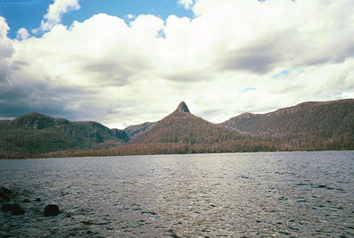
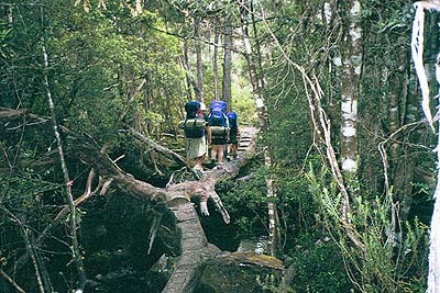
It’s amazing, when you want to get somewhere quickly by a slow means, how much longer it seems to take. Trudging out from Pine Valley to pick up the Overland Track again seemed to take forever, and that was to get to a point that we had departed from 2½ days earlier. By the time we had reached Windy Ridge hut (effectively less that one day’s walk from the start), we were all spitting and snarling. Joseph was refusing to move his boots one more step, and I was threatening to use mine to hurry his pants along (well, not really, but it sounds more dramatic when put like that). After an extended lunch including a long cards sessions (any Uni student or senior public servant would be familiar with this) and enjoying viewing the Acropolis and Mt Geryon from the other side, we set off again over DuCane Gap, quite a vigorous climb from either side. Having earlier plagued all oncoming traffic with questions are to how far was Windy Ridge Hut, we now took great delight in telling exhausted parties how far they had to go, a sadistic pleasure which fuelled our own efforts and put a spring in our step.

The Acropolis and Mt Geryon from the other side, Windy Ridge Hut.We passed many groups at this time; families of up to a dozen or so with kids younger than Joseph and fathers struggling pathetically under combined weight of billy cans and teddy bears. “Poor buggers”, I smiled to myself, conveniently forgetting the fact that I was carrying the food, fuel and share of the tent of two boys who were each eating more food than I was.
One thing that astonished me, especially when passing nubile young couples, was their smells. Whether days away from sense-deadening cities had made me more “olefactorily aware”, or whether they just felt they had to smell stronger to mask more b.o., I don’t know, but passing some couples was more like walking through the “ladies’ paint-and-sniff” counters of Grace Bros. or D.J.’s. Still, I guess you never know when you might bump into some marsupial mayor or rodent royalty. Or were they trying to impress each other??? “Five days into the track and smell me!!! I’m still a rose! Aren’t I amazing?” Maybe I was envious of the fact that they could afford to carry the extra two hundred grams of underarm pong repellent.


Doo, doo, doo, looking out my back door. Hartnett FallsTruly, sometimes I could smell people coming before I could see them. This got me thinking. I wonder if they could smell the subtleties of the bush that I seemed to be experiencing. The native beech forests were wonderfully musty and spicy, and later we would be brushing past boronias in full flower, filling our noses with their fragrance. But what were these walking perfume-counters smelling? Then it struck me… By dousing themselves scentsless, they would avoid smelling stinky unwashed bastards like me!!!


Having crested the lofty and scent-laden DuCane Gap, we found a campsite that night that made me think we had died and gone to Hikers’ Heaven. (Come to think of it, the early climb had nearly killed us!) We pitched tents on a soft leaf litter surrounded by native beech forests, twenty metres from a waterfall on the Mersey River. Feeling in need of a swim, we stripped off - swimmers were far too heavy to carry - and skated across the rocks before plunging in. The water was indeed very very cold, reducing all claims to manhood to a mere vestige, but the skating was not due to ice but slippery moss, which in fact was what caused the plunging. The boys turned this to their advantage, creating a water slide to slip down.
Dinner, including a dessert of custard and stewed apricots, was cooked and voraciously eaten above the waterfall, the rock platform providing enough tables for all parties, even though none of us had booked ahead.
As the sun set on our literally gorgeous b.y.o.d. (bring-your-own-dinner), I couldn’t help thinking that folks would pay a hundred dollars a head to eat like this. All you need to do is invest in several hundreds of dollars of camping gear, walk several days to starvation to hone your appetite, and it could be yours for free!

As seen on Andrew Purdam's Bushwalking Treasure Box blog.

21 May 2010

Overland Track Jan 2000 - Day 3

The Acropolis

The other day walk available to us from Pine Valley is to climb westward into the Labyrinth. This is a beautiful area covered in tarns and surrounded by rocky peaks. For some reason, it is also infested with the most aggressive ants I’ve met. As soon as you placed a foot anywhere, they would start to converge. Must have been the echidna’s day off…
View from the Labyrinth

Above: The three-headed Mt Geryon and The Acropolis from the Labyrinth. Lake Elysia is in the foreground.

Many of the peaks, rivers and lakes in the district are named after classical Greek characters, which makes for a very dramatic way of interpreting the landscape. The Labyrinth is sometimes difficult for the neophyte to negotiate even in good weather. In a white-out, it would be deadly.


Above: 180º view, looking west, north and east from the Labyrinth. Left to Right: Walled Mountain, Lake Tartarus, Mt Eros, Mt Hyperion, more of the Labyrinth, Mt Massif, Mt Geryon and the Acropolis

Pine Valley and the surrounding day-walk areas - The Labyrinth and the Acropolis - make a brilliant introduction to the Cradle Mountain/Lake St Clair National Park. They are breathtaking, in every sense of the word! The Pine Valley campsite was fun, too, being well attended by pademelons (Rufous wallaby), including babies who would occasionally race through camp like a super ball, cornering as if they were ricocheting off the ground. The other animals to really welcome us here were the mosquitoes, but we’ll talk about them more later…


As seen on Andrew Purdam's Bushwalking Treasure Box blog.

16 May 2010

Overland Track Jan 2000 - Day 2

The Acropolis

The Acropolis (left) with about 600 metres of climbing, was the first and the most demanding day trip we did. Here are Helen and the boys stopping to breathe. Because of the height, it also offers some stunning 360 degree views, letting you look straight down the Lake St Clair valley (in background), as well as straight across to Mt Geryon, a very dramatic rocky outcrop. The Acropolis itself was covered in flowers. (Do excuse the clunky panorama, but it was compiled over ten years ago, before both ptgui and cheap archiving...)


Acropolis 270 degree panorama

Stitched from 5 and 4 photos using ptgui
270 degree from The Acropolis looking south and west, then north west to north east.
Top: From left to right, Mt Gould, the Labyrinth, Mt Eros, bit of Mt Geryon
Bottom: Mt Geryon, Mount Massif, Mt Ossa (b/g), Falling Mountain (and that's only the left half of the horizon!), and in the f/g a bit of the Acropolis.

The barrel distortion and dark fringes on this old camera were phenomenal, making for some badly banded panoramas.


As seen on Andrew Purdam's Bushwalking Treasure Box blog.

14 May 2010

Overland Track Jan 2000 - Day 1

Lake St. Clair to Pine Valley

This boat took us 14 km up Lake St Clair to Narcissus Hut, where we began our 11-day walk through to Cradle Mountain. The boat is leaning to one side 'cos of the weight of my pack, nearly 28kg (60 pounds)!


Mt Ida is about half way up Lake St Clair, on the eastern side. Strangely, Glen and Joseph didn’t get sick on this boat, despite losing their brekky on the Devil Cat. Maybe it’s 'cos they were allowed drive a bit on this boat (Lake St Clair is a long way to sink, but not too far to swim…).


Tassy Parks and Wildlife Service have had duck boards on wetter patches of the walks for decades now, to help control erosion. Whilst they definitely take away the impression of walking in the wilderness, they certainly help in reducing track erosion. In some spots without boards, the mud can be knee-deep, and the track becomes up to ten metres wide trying to avoid it. We saw very little mud this time, but enjoyed a good slorp when it was available. This is Mt Gould, as we trudge off towards Pine Valley, our first stop.

Fallen trees make a road in Pine Valley.

We decided to do the Overland Track south to north so that we could stop at Pine Valley for a few days and eat some food before having to shift camp again. This was a Good Idea.


As seen on Andrew Purdam's Bushwalking Treasure Box blog.

13 May 2010

Overland Track Jan 2000

Lake St Clair to Cradle Mountain


Well, after months and months of planning, the Purdam family finally got away for several weeks to tour Tasmania, including a 10½ day bushwalk on the Overland Track. We were blessed with perfect weather, despite it snowing two weeks before our trip, and four days after we’d finished. We’re still looking for the person who must have sold their soul to the devil for us to get such a great window in the weather. The 11 day trek was a wonderful challenge for the boys (then 9 and 12), who rose to the physical task admirably. We all became much fitter as we went on.

Rough calculations tell me that we walked about 120 kilometres and climbed over 5000 metres, over half of that height with packs on. Many people do the Cradle Mtn/Lake St Clair track in 4-5 days, and consequently miss a lot, often only climbing Mt Ossa and Cradle Mountain. Ascentaholics as we were, we saw this beautiful mountainous area from seven different peaks, including The Acropolis, The Labyrinth, Mt Ossa, Mt Pelion East, Mt Oakleigh, Barn Bluff and Cradle Mountain. Even though Mt Ossa (the highest peak in Tasmania) is not as high as Mt Kosciuszko, I think it should be considered Australia’s highest peak simply because it looks more like a mountain, the benefit of being in an area that was glacial during the last ice age.

  1. Lake St Clair to Pine Valley
  2. The Acropolis
  3. The Labyrinth
  4. Windy Ridge and Hartnett Falls
  5. Falls to Pinestone Valley
  6. Mt Ossa and Pelion East
  7. Mt Oakleigh
  8. Pineforest Moor and Lake Windermere
  9. Lake Will and Waterfall Valley Hut
  10. Barn Bluff and Lake Rodway
  11. Cradle Mountain
As seen on Andrew Purdam's Bushwalking Treasure Box blog.

08 May 2010

Frenchman's Cap Jan 2003 - Day 6

Mary Creek Plain to Victoria Pass

Sadly, the tent leaked profusely and puddles were very evident the next morning. I had devotedly seam-sealed all seams in the tent, but the rain sweated through where the floor joined the wall (a vulcanised bond). This was most disappointing, as both fabrics are supposed to be water proof, but I think the joining process has left them less than so. We later found a small hole in the floor and resealed the corners later, to make a much happier tent. During the night, the expelled leeches had gathered in the fly. Getting out in the morning then became a running of the gauntlet as the hungry little vampires had attached themselves to everything I had to brush past. The boys elected to have breakfast inside, but we all agreed to leave as quickly as possible.

Remarkably, the clouds broke and we ended up climbing up to Flat Bluff in sunshine. By the end of the day, sunburn was feeling unavoidable, despite the sunscreen. Flat Bluff was an incredibly beautiful place, covered in delicate plants and flowers. We felt like vandals even walking there. A very strange mix of emotions. We pushed on through increasingly scratchy scrub (richea scoparia) up to the Ragland Range, where we met the fire-trail.

Very easy walking which we thought we'd spice up by making a "short-cut" over Bub's Hill down to Victoria Pass and the Lyell Highway. Seemed pretty straightforward. The spur basically went down. As counselled by Aragorn in the Lord of the Rings, short cuts make long delays, and we found ourselves struggling through thickets of teatree and rainforest scrub as our deadline with the bus grew nearer and nearer, kids grew wearier and wearier, and parents grew crankier and crankier. However sheer grunt prevailed and we hit the highway in time. By now the temperature had resumed in the mid 30sC and we were very pleased to simply sit and wait for the bus.

The trip proved to be a really good mix of good fun, some big effort and grand views, spiced up with some traditional rain, hail and sunshine and a touch of vampirism.


Prev Index


As seen on Andrew Purdam's Bushwalking Treasure Box blog.

Frenchman's Cap Jan 2003 - Day 5

Irenabyss to Mary Creek Plain

Very few photos were taken this day (this one is of the rafting party departing from the opposite bank), as it rained incessantly and views were restricted. Despite a trail not being marked on the map, there is a pad (in places indistinct) to follow up from the Irenabyss, and most of the way to the Mary Creek plain. It rained and rained and rained, making lunch pretty cold and miserable. However the landscape was still beautiful. We reached the Mary Creek plain and discovered that it is a very wet button-grass plain. Not muddy - because there was no track - but extremely wet underfoot and very uneven. Broken ankles felt inevitable but fortunately none eventuated.

We searched for flat spaces to camp but alas there are none. Anything near flat was muddy. It was whilst we were scouting (ultimately unsuccessfully) for good camping sites that we realised Mary Creek's other great minus - a secret hidden amongst the grass. It was crawling with leeches. The combination of the weather and leeches made this stopover particularly unpleasant, and there was little else to do other than hastily erect our tents, dive in them and spend the rest of the day finding leeches on our clothes and removing them into the fly of the tents!


Prev Index Next

As seen on Andrew Purdam's Bushwalking Treasure Box blog.

03 May 2010

Frenchman's Cap Jan 2003 - Day 4

Lake Tahune to Irenabyss

Drops on lily flowerIt rained that night, alarming us with some moisture at the feet of our sleeping bags. We had paid a lot for this tent, as storm-proof (okay, storm-resistant) four-person tents are very hard to come by, and were disappointed. What if it rained a lot? That does happen in Tasmania. Anyhow, the overnight rain had made for a good photo opportunity, which Joseph made the most of. We decided to ignore the coming weather and walk out from Frenchmans northwards, rather than back the way we came. This meant descending 1000 metres to the Irenabyss, crossing the Franklin river without a bridge, at a point that is not fordable (either swim or paddle), and walking out over the Mary Creek Plain - another soggy bog (with a surprise creature awaiting us, more of that tomorrow). Sounded like fun.

As we left to climb North Col a second time (this time with packs on), it started to hail. Then - in typical Tasmanian highland in summer fashion - it started to snow. We were delighted as the exposed quartzite became even whiter. By the time we left the North Col, however, it had hailed again, an icy, sleaty wind had whipped up, and we had an 8-9 km walk along an exposed ridge before our descent. Once we had reclothed the kids and ourselves in some warmer gear, we continued on. Finally, after weeks of alpine walking in good weather in the previous years, our preparation had paid off, and we didn't feel so nerdy about all our warm clothing.

Lake NancyThe track to the Irenabyss from Lake Tahune is as hazardous as it is spectacular. Following an exposed ridge above several alpine cirques, you then descend very steeply and "slipperily" to the Franklin River. Much of this is achieved on one's bum, mostly unwillingly. Here you perfect the art of falling on your pack, to avoid breaking arms and necks. After a chilling trip from Lake Tahune, we tumbled down to the Franklin river.

We were ready. We had carried lilos in to cross the Franklin river, however all that was rendered unnecessary when a rafting group arrived. They wanted to camp there, too, and agreed to carry us across in exhange for letting them use "their" site. We were happy to oblige, as the northside campsites were nicer, though smaller. Despite the earlier chill of the day, we paddled up the Irenabyss on our lilos. This is a deep chasm cut by the river and the river slows down appreciably. Paddling through and just lying there looking up at the walls is very peaceful.

The Franklin river is much warmer than Lake Tahune, made obvious when you paddle over to where Tahune creek joins. Freezing!

There are some remnant Huon pines on the Franklin here, too. Most Huon pine has been removed from Tasmania by loggers over the past one hundred years and the Tasmanian environment continues to be threatened by rapacious logging.

Prev Index Next


As seen on Andrew Purdam's Bushwalking Treasure Box blog.

02 May 2010

Frenchman's Cap Jan 2003 - Day 3

Frenchmans Cap

Panorama East from Frenchmans Cap

There is no way to do this view justice with photos. The panorama above was assembled from about six photos. I did a second layer to get more of the feeling of height, but it was too distorted! The eastern face of Frenchman's Cap - shown left - at over 300 metres (1000 feet), is the sheerest vertical drop on the Australian continent (and makes for great rockclimbing). In the pic above, you can see Sharlands Peak, Barron Pass (about 1/4 way along) and Philps Peak. Below Philps are Lakes Cecily, Gertrude, Magdalen and Millicent. Clytemnestra is shown from the north and above, this time.


There's no mistaking, this is why you walk through over half a day of mud and climb up and down hundreds and hundreds of metres. On the clearest of days, you can see to the coast, to peaks in Cradle Mountain-Lake St Clair NP, and in many directions it is easy to ignore any sign of human intrusion.

In the middle of the photo to the left you can just see some specks on the "knee" of the edge, probably Glen and Joseph. They like heights.


Right, two families atop Frenchmans. Back row, us Purdams, Glen, Helen, Andrew and Joseph. Front row, Sally, Matt, Jenny and Glen.


Lake Tahune mood shotBy the time we had descended, some cloud had blown in, billowing over Frenchmans Cap. If we had stayed at Lake Vera the previous night, we would have had a much more restricted view from the top of Frenchmans that afternoon. It rained that night, hailed and snowed the next day.


Prev Index Next

As seen on Andrew Purdam's Bushwalking Treasure Box blog.

01 May 2010

Frenchman's Cap Jan 2003 - Day 2

Loddon River to Lake Tahune

The Loddon Plains are button-grass plains, and over the years, wear and tear from walkers has penetrated the thin shell of soggy vegetation, bursting down to the muddy layer beneath. In places, this mud is nearly waste deep. Environmental etiquette demands that you walk through the middle of the mud, to avoid making the track wider and braided. One can make two points on this:
1. Wading through deep mud is exhausting and treacherous on knees and ankles, as you can't see the surface your feet are trying to get a purchase on.
2. Many folks aren't playing the game, as the track is braiding and spreading up to about ten metres wide, making it look more like an Amazonion estuary
Whilst a fair bit of trackwork has been done here, I can see that Tassy Parks will probably stop soon. The mud keeps the numbers down in the park!

We lunched at Lake Vera. The plan had been to stop and overnight here, but weather predictions suggested that we best be on Frenchmans Cap tomorrow sooner rather than later.


The climb from Lake Vera to Barron Pass is about 300 metres or so and fairly steep. It runs alongside a rushing stream for much of the time before climbing into the pass. The view is huge, absolutely breathtaking (the climb has something to do with this) and very hard to photograph. The panorama above is made up from about ten shots in two layers. Left is White Needle, about 500 metres away and another 100 metres up. The three lakes are Gertrude, Magdalen and Millicent, 2-7 km away and 500 metres below. Above them is Clytemnestra, 8km distant and 100 metres up. The eastern face of Frenchmans Cap is obvious, though bigger than it looks on the photo. It is about 6-7km away and another 500 metres above us. To the right is Sharlands Peak and some of Nicoles Needle, 50 metres away and 100 metres up.

Looming 500 metres above, yet still over a kilometre away, Frenchmans Cap completely dominates the Lake Tahune valley, gouged out by a glacier millions of years ago. 22 years ago, this made a great photo (twice as high) with the lake in the bottom. In that time, though, trees and shrubs have grown, and the lake is no longer visible from the hut. The dead white tree trunks are skeletons of King William Pines, excruciatingly slow growing native pines that were burnt in Tasmania's worst bushfire in history (it obliterated the south half of the state, killing many people) back in the 1960s. Because they are so slow growing, it will be centuries before they become visible in this area again.

Telopea flowersThe Artichoke Valley and Lake Tahune area are amazing pockets of microclimates for all sorts of interesting flowers, many of which are in bloom in January. The Telopea (called Waratah in NSW, where most telopea species are found) is a remarkable flower both in its form and colour. The whole Frenchmans Cap area never ceased to delight, on both the large scale and the small.


Prev Index Next


As seen on Andrew Purdam's Bushwalking Treasure Box blog.