28 June 2010

New Zealand Jan 2006 - Wilkin River

Wilkin River revisited

A walk that had tantalised Helen and me for a while, was to walk up the Wilkin valley, over Rabbit Pass and down the East Matukituki. We dragged to boys back to New Zealand in January 2006 for a one-off whirlwind trip which proved to be A Ford Too Far...

Azure Wilkin RiverWe took the jetboat up the Wilkin to Kerin Forks (where Siberia Stream, mentioned in a previous walk joins the Wilkin) and commenced our tramp. We actually got off the boat well after midday, due to timing of public transport, but it was still enough time to get to Top Forks Hut, as the NZ summer days are light til after 9pm.
Walking alongside the river, it was fairly flat except for the up-and-down bits... There is a prominent hill directly adjacent to the river, a route which must be taken in high water, but we were able to clamber/wade around the side of it on this trip.


Wilkin River ViewNext day, we planned a day-trip up the Wilkin's North Branch to Lakes Diana, Lucidus and hopefully Castalia. Here we see Mt Pollux and Mt Castor in the background as we head off. Helen took this one.


Lakes above Top ForksWe spent several days at Upper Wilkin Hut, waiting for weather, and hoping Joseph's back would improve sufficiently for us to continue our walk. Our walk to the lakes was thwarted by some typical NZ mountain weather, which is capable of making it both stunningly beautiful and miserable at the same time...


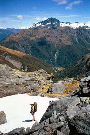
Pink icingBy this time (day 4), it had been decided that we would not continue with the whole party over Rabbit Pass as planned, and that we would simply walk back out the way we came. However, Helen and I wanted to see what Rabbit Pass was like, so we got up early enough to see the sun rising on Pollux (or Castor) before taking off up the South Branch.


Waterfall Face from Waterfall Flat
Waterfall Face from Waterfall Flat, Upper Wilkin, South Branch. The Wilkin River falls on the left are 50m, but the Mt Taurus Falls on the right are 400m!!! The 150m climb of the tricky (some would say treacherous - depending on the weather) Waterfall Face is right in front of us.


Helen, Rabbit PassHowever, climb it we did, in fact we climbed up it, and back down (since this was a there-and-back-again day trip to Rabbit Pass). Tricky even in good weather, the Waterfall Face becomes virtually impassable for trampers in the wet or under snow. Here, Helen is descending on our return trip, which we found much more difficult than climbing up.


Upper Wilkin Valley
That day, we saw only two other parties. The one who took this picture, (behind us is the top of the 400m Mt Taurus falls), and a party much later on, as we were descending back to the hut. They had flown into Jumboland early in the day, and were walking from there up to Waterfall Flat in the one day. Several of them were in their fifties or sixties, and they were as tough as nails! Even though we walked only 13km that day, we ascended 800m, and descended the same.


Wilkin River viewAll that was left was to walk out from Top Forks hut the next day. We had to ford the Wilkin at Kerin Forks to continue on the true left bank, but were eventually able to flag a jet boat to come back to pick us up (much to the jet boat driver's annoyance and our expense). Even though we had many great memories of the beautiful area that we got into, we couldn't help feeling that we had missed the target here, and this is a walk that may see a repeat performance some time in the future.


As seen on Andrew Purdam's Bushwalking Treasure Box blog.

21 June 2010

New Zealand Jan 2001 - Tongariro Crossing

Day walk to Mt Ngauruhoe, Red Crater, Blue Lake. Tongariro Nat Park

With only four weeks in New Zealand, there is much that you have to simply decide you won't get to see. For us, that was most of the North Island. However, Helen and I couldn't resist the temptation to slip in just one more walk, much to the boys' consternation. In the end, we agreed to leave them watching videos whilst we headed off to walk across the Tongariro.
Our late start was a blessing, as we didn't find any crowds until the South Crater, shown on the left here, below Mt Ngauruhoe. We were unaware that folks were able to climb Mt Ngarauhoe, which was squirting some steam out at the time. Then again, it had its head in the clouds only half an hour earlier.
The Tongariro Crossing is like walking across Mars. Bare, rocky, dry, windy, cold and not enough oxygen. The colours in some of the rocks are pretty amazing, though, as you can see from the two shots of Red Crater below. Emerald Lakes, whilst smelly, aren't even warm.


Red Crater Panorama

Emerald Lakes Panorama

Below, left to right, Mt Ngarauhoe, Red Crater in front of it, Central Crater, Mt Tongariro above it, Helen, Blue Lake and Mt Rotopaunga above it.
Blue Lake Panorama

As seen on Andrew Purdam's Bushwalking Treasure Box blog.

20 June 2010

New Zealand Jan 2001 - Abel Tasman National Park

We sped north through dull Greymouth, skirted Punakaiki's pancake rocks for a later visit, and made straight for Motueka on the west side of Tasman Bay.
Joseph was too young for us to hire any sea-kayaks, so we walked along the Abel Tasman National Park's paths. This proved to be quite a good choice, as there were only dozens of walkers on the tracks, but there were hundreds of kayakers on the water.
This was a real change of scene, and the only part of the South Island that makes you think of warm climate and palm trees.
Here I met the weta (pronounced witta, which the local person told me only comes out when it's wit).
[Actually, it turns out to be a huhu beetle - and no I didn't make that name up]

It must still rain a lot here, though, as there were lots of tree ferns. There were also lots of sand-flies. Around the campsites, there are feral possums, too, one bailing up Joseph in the dunny at Te Pukatea. The cove of Te Pukatea is simply gorgeous (see photo below). This part of the coast has very large tidal variation (over two metres), making for lots of variety in the bays, and making some estuary crossings impossibly impassable at high tide, so you need to time your walk carefully.


Glen had decided that the sandy paths made for walking in bare feet, leaving him so sore the following day that he and Joseph were dispatched by boat to a spot further north, whilst Helen and I enjoyed a day of unfettered tramping, and sprinted up the track to meet up with them that afternoon.
The last day was a quick walk to Totaranui Beach followed by a boat ride back to Marahau and a drive to Picton to cross over Cook Strait the next day.


As seen on Andrew Purdam's Bushwalking Treasure Box blog.

17 June 2010

New Zealand Jan 2001 - Young Valley, Gillespie Pass, Siberia Valley

Young Valley, Gillespie Pass, Crucible Lake and Siberia Valley

We thought we had seen bad sandflies in the Rees/Dart walk. At Milford Sound, we had seen seals sunning themselves in a breeze to keep sandflies off them. Nothing had prepared us for the onslaught of sandflies at Young Forks. Created as a lunching spot on the way to Young Hut, the rangers failed to mention whom it was lunch for. As it turned out, you'd have to say we had fast food for lunch that day.

With two walks under our belts, Helen and I were hoping that the boys would have "hardened up" to walking a bit by now, but Joseph proceeded to fall to bits as the Young valley continued to go up and up and up. It is really gorgeous, with lots of trees, the odd dangerous landslip to cross, and constant riverside stimulation, but not much mitigated it for a ten year old who had had enough. However, there was little else to do but trudge on and whinge, so that's what we did. (Before you report us for child abuse, please consider that only the other day Joseph was remarking how lucky he was to have seen such beautiful mountain areas. I guess time heals all wounds).

We finally reached Young Hut late in the day. To say the setting is worth it is an absolute understatement. Nestled at the lip of a glacial valley, above a waterfall which topples into a densely treed forest valley (the one we struggled up), and backed by a punchbowl of snowcapped cliffs, complete with slow combustion stove, Young Hut seemed like we'd all died and gone to heaven.

The next day (day two), we had to climb over Gillespie Pass. Only about 800 metres, but very steep for a long time. Again, the weather was very kind, and we didn't have to battle the blizzards experienced by folks several days earlier. We met a falcon at the very top, which circled us inquisitively before landing and showing us how much it could ignore us.


That night we camped near Gillespie Stream, in Siberia Valley. Stupidly, we camped under the trees, and again became dinner for the sandflies. Our own dinner was very quick, and a card game in the tent was quickly arranged as our evening's entertainment.


Walking on airThe climb up to Crucible Lake started and ended quite vertically, and in the middle there was a gentle rise, punctuated with a leap across the creek.
So whilst it looks like Joseph is walking on an invisible tightrope, he was actually trying hard to stay airborne enough to clear the creek, in which he succeeded.


Day three saw us visit Crucible Lake. Yet another fairly vertical climb up the other side of Siberia Valley into the feeder valley of Crucible Stream, itself fed by ice falls from the cliffs that surround it. It is well named, being a lake formed by a terminal moraine and backed by rock walls.

By the time we got to Siberia Hut, we were all feeling pretty tired, especially Joseph. Greeting us when we arrived were folks from Israel, Germany, France, Canada and New Zealand, and Glen and Joseph very quickly joined in an internationally uniting card game of Ricketty Kate.
The next day, we had to decide on whether we were going to get dropped by plane up at Jumboland, to walk on to Kerin Forks and Lake Lucidus etc or just catch the plane out. Torpor decided for us, and we were granted a lovely view of the upper Wilkin River valleys, including bird's eye views of the upper lakes. The pilot was very nice to Glen, explaining how to fly the plane, whilst we approached a cliff face at 200 kilometres per hour. He was very good at showing us how to turn tight corners.


As seen on Andrew Purdam's Bushwalking Treasure Box blog.

14 June 2010

New Zealand Jan 2001 - Mt Cook area

Mueller Hut

As if to make up for the bad weather of the coast, Aoraki (Mt Cook) allowed itself to be in full view for us for over two days. It is another stunning place to visit, with several glaciers quite accessible. It does rather startlingly underline the fact that NZ is full of falling down mountains. Much of the Hooker Valley is below scree slopes, leaving it looking more like a quarry than a national park. However, as one gets higher (and further away from the "mess"), one can take a more sanctified view of the whole area (probably caused by altitude sickness).
We had chosen to overnight in Mueller Hut, being the lowest hut (a mere 1000 metres above the car park) as well as the most accessible.

It took several hours to climb up the side of Mt Olivier to get to Mueller Hut. To make the feat achievable by the boys, Helen and I took all their gear (we didn't need tents) so that they could go up without packs. This made the feat much more of a challenge for us parents, as we struggled yak-like up the steep slopes.


We celebrated our arrival at Mueller Hut with some snow cones. God, snow is gritty...
Aoraki is doing Phantom Mountain imitations.


Click on the pic for a larger view, or click here for an enormous view!
Meuller Glacier, Aoraki/Mt Cook Nat Park, NZ
270° Panorama stitched from 11 portrait prints(!).
L ro R: Lake Pukaki (in distance), Helen, Mt Ollivier (sic) and Sealy Range, Mt Burns at the top of the Mueller Glacier, Main Range's Mt Isabel and Mt Thomson, highest point Mt Sefton (3162m) dropping down to the Footstool and finally to the Hooker Glacier, over 2000m below Sefton.
Aoraki/Mt Cook is the white blob 2800m above Hooker Gl.

As seen on Andrew Purdam's Bushwalking Treasure Box blog.